Skip to content


Details of New TOPO AUS/NZ map system released today by Garmin…………………
-
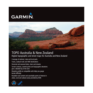 Includes topographic and street maps for Australia and New Zealand.
- Provides terrain contours at 20 m (65 ft) intervals, approximating 1:100K maps.
- Contains tracks, outback trails, 4WD destinations, perennial and seasonal lakes, rivers and streams.
- Topographic terrain contours and summit points provide a detailed lay of the land.
- Provides searchable points of interest in urban, rural and outback areas, including lodging, restaurants, camping locations, homesteads, caravan parks, shopping and more.
- Includes famous outback routes, such as Birdsville, Strezelecki, Oodnadatta, Canning Stock and more.
- Routable road content provided by NAVTEQ, and additional content provided by HEMA and LINZ.
- Includes coverage of national, state and local parks, plus forest and reserve areas.
- Provides elevation profile on compatible Garmin devices so you can estimate terrain difficulty.
- Includes BaseCamp™ software (DVD only), allowing you to view and manage waypoints, routes and tracks on your computer and GPS, as well as organize trip data into folders. This application includes useful planning tools, rotated map orientation, 2-D and 3-D map views, animated playback, photo geotagging, enhanced printing and more.
The post NEWS: Garmin releases details of updated TOPO Aus/NZ maps appeared first on Highly Tuned Athletes.